Application Overview
The VEM Common Operating Picture dashboard is built on ArcGIS Experience Builder and provides a comprehensive situational awareness dashboard for internal use by Vermont Emergency Management.
Application Structure
The COP dashboard is generally organized into the following primary components:
🌐 VEM-COP Experience Builder Application
├── 📝 Situational Awareness Page
│   └── 🗺️ Situational Awareness WebMap
│       ├── 📜 Active Incidents (Feature Layer)
│       ├── 📜 Weather Radar (Image Service)
│       └── 📜 Etc.
│
├── 📝 Weather Page
│   └── 🗺️ Weather WebMap
│       ├── 📜 NWS Watches & Warnings (Feature Layer)
│       ├── 📜 NOAA Precipitation Forecast (Feature Layer)
│       └── 📜 Etc.
│
├── 📝 Fire Risk Page
│    └── 🗺️ Fire Risk WebMap
│         ├── 📜 Vermont Fire Danger (Feature Layer)
│         ├── 📜 Current Wildfire Incidents (Feature Layer)
│         └── 📜 Etc.
│
├──📝 VT Outages Page
│    └── 🗺️ VT Outages WebSite
│
├── 📝 Mass Care Page
│    └── 🗺️ Mass Care WebMap
│         ├── 📜 AHS Shelters (Point Layer)
│         ├── 📜 ARC Shelters (Point Layer)
│         ├── 📜 ARC Trailers (Point Layer)
│         └── 📜 Etc.
│
└── 📝 Infrastructure Page
    └── 🗺️ Infrastructure WebMap
        ├── 📜 TBD
        └── 📜 TBD
Maps
Multiple map views provide different perspectives on Vermont's emergency management landscape:
- Situational Awareness Map: Real-time view of current conditions
- Weather Map: Detailed meteorological data, forecast, and warnings
- Fire Risk Map: Daily fire danger forecasts and preparedness levels
- Power Outages Map: Statewide power outage accessed via VT Outages
- Mass Care Map: Location and status of Vermont mass care resources
- Infrastructure Map: Real-time road closure data (available during SEOC activation)
See the Maps section for detailed documentation.
Data Integration
The COP integrates data from multiple sources:
For example:
- Vermont 511 traffic information
- National Weather Service alerts
- Power outage data (vtoutages.org)
- VT 211 call locations
See the Maps section for detailed information about data sources and related attributes.
User Interface Layout
Preview screenshot of the COP interface
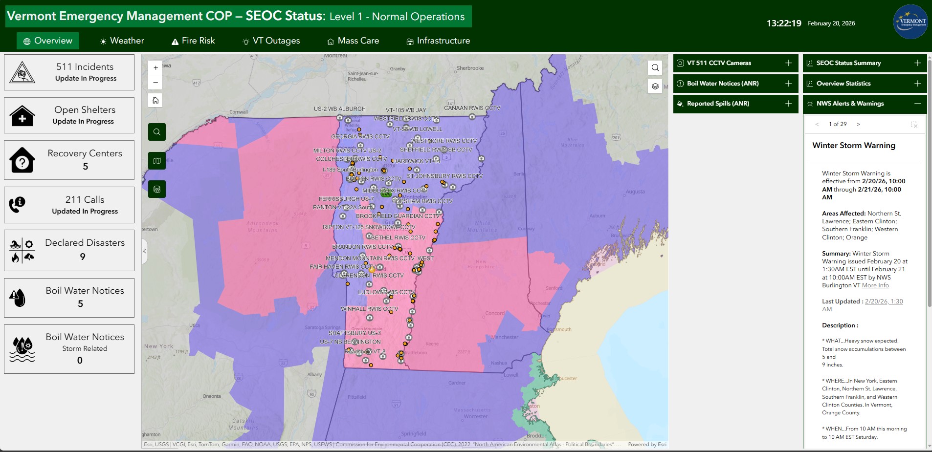
The application uses a fullscreen layout with the following components:
- Header: Application title, dynamic status text and color, date/time, and logo
- Navigation: Tab-based navigation between different views
- Map Area(s): Primary interactive mapping area
- Side Panel: Widgets for data display and interaction
Key Technologies
- ArcGIS Online: Data hosting and map services hosted in: VEM AGO
- ArcGIS Experience Builder: Application framework hosted in: VEM AGO
- Arcade: Expression language for symbology and popups
- Python: AGO hosted Python notebooks that support ETL workflows
Access and Permissions
Access Requirements
The VEM COP requires authentication through ArcGIS Online. Contact your VEM administrator for access (either Brett Pierce or John Van Hoesen).
User Roles
- Viewer: Read-only access to maps and data
- Editor: Can update certain data layers
- Administrator: Full access to configure application
Browser Compatibility
| Browser | Minimum Version | Recommended |
|---|---|---|
| Chrome | 90+ | Latest |
| Firefox | 88+ | Latest |
| Edge | 90+ | Latest |
| Safari | 14+ | Latest |
Mobile Access
While the COP is accessible on mobile devices, full functionality is optimized for desktop browsers with screen resolution of at least 1280x720.
Performance Considerations
The application is designed for optimal performance, but some factors can affect speed:
- Network Connection: Broadband recommended for real-time data
- Browser Extensions: Ad blockers may interfere with map loading
- Cache: Clear browser cache if experiencing issues
Support and Feedback
For technical issues, feature requests, or questions:
- Email: John Van Hoesen
- Phone: 802-498-5702